MANAGEMENT OF AQUATIC ENVIRONMENTS AND FLOOD PREVENTION (GEMAPI)
in Pays d’Opale
GEMAPI : Management of aquatic environments and flood prevention
The GEMAPI is a responsibility delegated to intermunicipalities by the decentralization laws No. 2014-58 of January 27, 2014, and No. 2015-991 of August 7, 2015, since January 1, 2018.
What are the tasks?
Guided by French and European regulations on water, aquatic environments, and the environment, the GEMAPI’s tasks are outlined in the 4 paragraphs of Article L.211-7 of the Environmental Code:
→ Develop a hydrographic basin or a portion of a basin, including storage facilities in reservoir lakes,
→ Maintain and develop a watercourse, canal, lake, or water body for reasons of urgency or general interest, especially in the case of widespread neglect by riparian owners,
→ Ensure defense against floods, notably through the construction and management of levees,
→ Protect and restore sites, aquatic ecosystems, and wetlands, as well as adjacent wooded areas, including the restoration of ecological continuity.
The municipalities of CCPO have chosen to add to the community’s competencies:
→ Combating soil runoff and erosion, managing mudflows.
What is the organization of competence?
The community of municipalities defines the tasks it directly manages and those it entrusts to other organizations to address water-related issues (runoff, erosion, flooding, water quality, etc.).
On a coherent hydrographic scale, which is that of the watershed to manage GEMAPI issues, the CCPO can indeed transfer or delegate all or part of the competence to common law or specialized mixed unions – EPAGE or EPTB.
Decisions regarding the implementation of studies, work, or actions are then made by the competent structure.
A watershed is a portion of territory delimited by watershed lines and irrigated by the same hydrographic network (a river, with all its tributaries and all the watercourses that feed this territory).
Within the same watershed, all received waters converge towards a common outlet called an outlet. Soil erosion is a natural phenomenon resulting from the removal of the surface layers of soil and the displacement of its constituent materials. It reduces the productivity of the land and contributes to the pollution of watercourses, wetlands, and adjacent lakes.
*EPAGE: Public Institutions for Water Development and Management
**EPTB: Public Territorial Institutions of the Basin
Who manages GEMAPI in the area?
The territory of the Pays d’Opale Community of Municipalities is divided based on watersheds and their various issues and challenges. Joint associations manage aquatic environments and flood prevention to varying degrees depending on the specificities of each.
Originally established in response to numerous floods experienced by watersheds, joint associations have diversified to include the management of aquatic environments. Two of them carry a Water Development and Management Plan: the SAGE.
The SAGE is collectively developed by water stakeholders in the territory gathered within a deliberative assembly, the Local Water Commission (CLE).
Joint associations carry and/or implement Action and Flood Prevention Programs: the PAPI, which promote integrated risk management to reduce the harmful consequences of floods on human health, property, economic activities, and the environment.
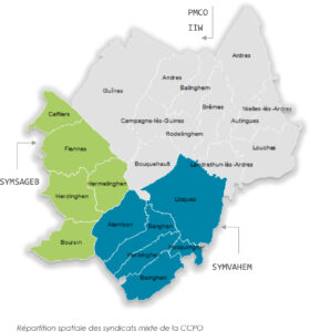
SYMSAGEB: Joint Association for the Boulonnais SAGE – Boulonnais SAGE and PAPI
SYMVAHEM: Joint Association for the Valley of HEM – HEM PAPI
IIW: Intercommunal Institution of Wateringues – Aa Delta SAGE and PAPI
Don’t confuse the Intercommunal Institution of Wateringues with the sections of the wateringues (associations of owners, organized in administrative commissions). The latter are not funded under GEMAPI.
SYMSAGEB and SYMVAHEM manage the entire GEMAPI competence as well as the fight against runoff and soil erosion in their territory.
In the territory of the hillsides and the maritime plain, several actors are involved in managing the competence.
IIW, from Sangatte to the Belgian border, ensures the mission of evacuating water from the polder to the sea, depending on the tides, through five sluice gates, as well as hydraulic protection by pumping this maritime plain representing 85,000 hectares. IIW also conducts studies on canals that are no longer navigable in order to extend its competences to them (VNF manages navigable canals). It is currently revising its statutes to also integrate the management of aquatic environments.
CCPO collaborates with many partners according to their areas of responsibility, such as GDON, which organizes the fight against the muskrat, CEN (Conservatoire des Espaces Naturels) for wetland management (Pont sans Pareil), and EDEN 62, a joint association representing elected officials from the departmental council and local authorities. Eden 62 manages Sensitive Natural Areas (ENS).
All joint associations, as well as CCPO, prioritize consultation with all stakeholders who are involved: wateringues associations, public and private property owners, farmers, infrastructure managers, and more.
What actions are being taken?
The CCPO, unions, and local stakeholders are jointly managing water and aquatic environments on the scale of their watershed and within their areas of expertise. Actions are undertaken as part of SAGE and PAPI and typically involve several stages before realization. Preliminary studies before the implementation of works are often necessary to have a reliable project in compliance with regulations.
The CCPO
It oversees the missions of various unions by appointing representatives to various union committees. Technicians are also involved in the studies and projects being undertaken.
A program ARARAT 2, including more structuring structures (retention basin – indented ditches), is under study for the basin of the 4 winds and the grounds of Andres. A program for the development of structures to combat soil erosion and runoff is under study to cover the entire territory from the foothills, especially in Ardrésis.
The CCPO has entrusted the management of the natural site of “Pont sans pareil” to the Conservatoire des Espaces Naturels (CEN), a wetland located in the town of Ardres. This site has ecological significance and contributes to ecological continuity with the regional nature reserve of Pont d’Ardres.
The GEMAPI competence is transferred to the following basins: SYMVAHEM, SYMSAGEB, IIW.
Eden 62 manages 3 wetlands in the CCPO territory. The actions undertaken include: the development of a management plan, site maintenance, public reception, and animation for the discovery of natural heritage.
The Natural Sensitive Area of “Communal d’Hardinghen” is a wet meadow bordered by hedges and wooded areas, dotted with small depressions, with the presence of two ponds and two groves. It is located in and belongs to the town of Hardinghen. It has an area of 13 ha, of which 10 ha are covered by the provision agreement 2011-2036. A Management Plan is developed for the period 2012-2021 (8th year of execution). The current challenges of the site include the vegetation and species developing within aquatic and amphibious environments, as well as species benefiting from the network of hedges and the presence of riparian woodland.
The Natural Sensitive Area of “Marais du Calaisis” is a vast marsh basin traversed by multiple channels and punctuated by former peat bog pits, which allowed the development of aquatic, amphibious, and hydrophilic vegetation under various stages of maturation. It consists of two Natural Sensitive Areas: “Marais de Guînes” and “lac d’Ardres.”
It is located in the municipalities of Andres and Guînes, and it belongs to the Department of Pas-de-Calais. Its surface area is 14 ha (No acquisition in 2019). The Natural Sensitive Area of “lac d’Ardres” is owned by the Department of Pas-de-Calais and covers 163 ha. The main challenges of the site are the vegetation and species developing within different stages of evolution of aquatic, amphibious, and hydrophilic environments.
Erosion and Runoff Control
The Community of Communes Pays d’Opale is actively working to combat soil runoff and erosion.
Soil erosion, what is it?
When the earth breaks apart under the influence of rain and runoff, this phenomenon is called water erosion of the soil. It can give rise to muddy streams.
How is it impactful?
Runoff and mudslides can affect homes, roads, as well as streams and canals. This phenomenon impoverishes agricultural plots as the most fertile part of the soil is eroded.
The CCPO, a sensitive area?
The territory of the CCPO is sensitive to this phenomenon, which is far from negligible. Human factors such as soil sealing and agricultural practices, as well as natural factors like rainfall, topography, or soil characteristics, influence this phenomenon.
Is this a concern?
Erosion protection is a key issue for the CCPO and involves preserving the agronomic quality of agricultural soils, carbon storage, and enhancing the quality of wetlands and watercourses.
Muskrat Control
Since January 1, 2018, the Pays d’Opale Community of Communes has been supporting the GDON (Groupement de Défense contre les Organismes Nuisibles du Calaisis) in the fight against the proliferation of muskrats throughout its territory. GDON is now the organization capable of providing answers to trappers and individuals regarding this issue.
M. Nicolas DELEGLISE – Président
22 rue du village – BP 5074 – 62610 Nielles-les-Ardres
Tel: 06 62 87 05 60
Mail: mariethe.nico@free.fr
Facebook: https://www.facebook.com/GDONducalaisis/